Welcome to Advanced Interactive Web Mapping, Programming, and Design, Class 2
This is a web page that can be viewed as slides.
→ to move forward
← to go back
Advanced Interactive Web Mapping, Programming, and Design
Class 2
CartoCSS
why?
styling maps can be painful
you can share it
you can share it
(it's just text)
CartoCSS
#earthquakes {
    marker-fill: #ff307a;
    marker-line-color: #FFF;
    marker-line-width: 0.25;
    marker-line-opacity: 0.4;
    marker-width: 2;
    marker-allow-overlap: true;
}
property values will often be color strings, numbers, or boolean (true/false)
that's nice, but it gets more interesting
let's vary some properties by zoom level
#earthquakes {
    marker-width: 3;
    ...
    [zoom >= 10] {
        marker-width: 8;
    }
}
let's call these conditional statements
conditional statements are only used if some condition is met
#earthquakes {
    marker-width: 3;
    ...
    [zoom >= 10] {
        marker-width: 8;
    }
}
#earthquakes {
    marker-width: 3;
    ...
    [zoom >= 10] {
        marker-width: 8;
    }
    [zoom >= 16] {
        marker-width: 13;
    }
}
that's not all!
you can change styles based on a feature's attributes
#earthquakes {
    marker-width: 3;
    ...
    [mag >= 6.5] {
        marker-width: 8;
    }
}
look familiar?
conditional statements containing text need to wrap those strings in quotation marks
#earthquakes {
    marker-width: 3;
    ...
    [place = 'Northern Mid-Atlantic Ridge'] {
        marker-width: 8;
    }
}
you don't have to memorize all of this
experiment with CartoDB's visualization wizards, see the code they produce
read other people's CartoCSS
but I wanted 6.5!
SQL
SQL
Structured Query Language
SQL
the language databases understand
you'll use SQL in two ways:
1. pulling data out of the database
2. changing the data in the database

Give me the pages that refer to properties in Brooklyn.
Give me the addresses of the properties in Brooklyn.
Give me the addresses of the properties in Brooklyn that have been built on since 1950.
databases are great at these types of questions
it's what they were made for
SQL helps you ask these questions in a way databases understand
CartoDB
SELECT: choose columns from a table
just list the columns:
SELECT students, teachers
FROM education
SELECT *: choose all columns
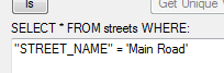
WHERE: choose rows from a table
these operators are the same as in most programming languages:
>
<
=
!=
>=
<=
for example:
SELECT *
FROM education
WHERE students > 100
and you combine them with AND / OR
for example:
SELECT *
FROM education
WHERE students > 100
    AND students < 200
or you can negate a condition with NOT
for example:
SELECT *
FROM education
WHERE NOT (students > 100
  OR op_type = 'religious')
SELECT does not change the table, it only changes your view of the table
you can also use SELECT to get a better idea of what data is in your table
count matching rows:
SELECT COUNT(*)
FROM education
WHERE students > 100
  OR op_type = 'religious'
but you'll almost never want to use this statement for your map
SELECT trick: add "columns" to your selection
SELECT *, 5
FROM education
SELECT *, stdnt_fem / students
FROM education
SELECT *,
    (stdnt_fem / students) * 100
FROM education
SELECT *,
    (stdnt_fem / students) * 100
    AS stdnt_fem_per
FROM education
1. pulling data out of the database
2. changing the data in the database
you can also use SQL to quickly UPDATE or DELETE the data in your table
these will destroy data, so have a backup or test it with a table you don't need
UPDATE education
SET size = 'large'
WHERE students > 2500
DELETE FROM education
WHERE ...
more in the SQL reference
SQL shows up everywhere online
that's a lot, but there's a little more
SELECT *,
    (stdnt_fem / students) * 100
    AS stdnt_fem_per
FROM education
SELECT *, ST_area(the_geom)
FROM kiberaboundary
SELECT *,
  ST_area(
    ST_transform(
      the_geom_webmercator,
      21036
    )
  )
FROM kiberaboundary
SELECT education.*
FROM education, kiberaboundary
WHERE
  kiberaboundary.name = 'Silanga' AND
  ST_within(
    education.the_geom,
    kiberaboundary.the_geom
  )
embedding CartoDB maps using iframes